Day 24 - Adventure trip to Clinton Creek and exploring Dawson City, Yukon Territory
Friday 7/14/2006
Erik really wanted to catch a big fish during this trip so we decided we should visit a local fishing spot. The kids had found a reference to a place called Clinton Creek, an abandoned gold diggers city, from the Mile Post book we are using. Given that it was a bit of a ride there, we started early. I concluded that we needed to get some fuel before heading out. We raced down into town, to buy the fuel, but we arrived one hour before it opened. So we returned back to the campground and hung around a little bit before returning down again. One of the lessons from this is to not make any assumptions about when service stations are open and instead to buy fuel beforehand. After we had fueled up we went over to the ferry and waited in line for a short while. There is no bridge over the Yukon River here so you have to take a ferry over it. We heard that they might be building one in the future. The crossing itself is quite fast. It takes less than 10 minutes from them waving you down to enter the ferry until you roll off on the other side.
Once we were over on the other side we were on what is also known as the Top of the world highway. During the first 10 minutes from the ferry we climbed about 3,000ft up to about 3,700ft. The road itself follows a mountain range. The views are quite nice. Isabella had done some read up on today's excursion. We had to travel about 36 miles along the highway, towards the US border, and then get off the main road onto an unmaintained gravel road. What she did not tell me beforehand was that we had to travel 25 miles on the gravel road!! Luckily we fueled up before going there because what he had before fuelup would not had been enough.

Leaving the pavement of Top of the World highway for Clinton Creek, Yukon

Reminded about the risks of the abandoned road, we continue
The side road to Clinton Creek starts off fine and then gradually gets more and more narrow. It was not bad with a 4x4, since the road was quite dry. But it was hard to go faster than 20 mph. We finally arrived at a bridge crossing the Yukon River. It was in enough disrepair that I had to inspect it before crossing. On the other side it was not clear where the old settlement was located so we ended up continuing on the road for a while after which we decided to turn around back towards the bridge.

Shall we cross? The bridge looks like to could use some fresh wood..

Where is this road going? The bridge was washed out so we crossed with the truck
The Milepost book was not very helpful here. It probably assumed that whatever signs might have existed there would still be around. We did some more trekking around with the truck in that area, crossing a smaller creek, without finding what we thought was the camp. We did find an oil barrel with the text "Private Property" painted on it, though. No signs of life or a house. We turned the truck around again. When we finally went back to the bridge we realized there was an abandoned parking area not far from it. Karl thought it was cool that the old Chevy truck that was parked there had bullet holes in the windshield. I did not think so. Once we got parked we took out our fishing gear and Erik started to throw the lure into the water. We kept working on this for and while, and Erik caught nothing. We thought he water looked a bit full of silt from rain, but we kept going anyway. We found some animal tracks in the mud. They looked like wolf tracks.

40 miles+ from nearest house: fresh, unfriendly, paw prints by the river that looked like wolf

Erik tries his luck at the abandoned gold mining town Clinton Creek
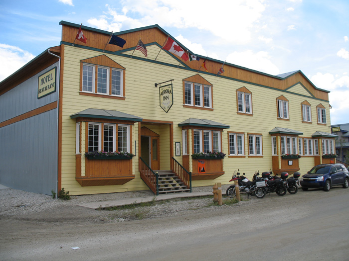
After we had stood there for what seemed like hours, we heard a strange banging noise. We looked up and saw two men on the bridge. It sounded like they were banging in nail heads into the wood. I asked Erik to check with those two guys if this was a good spot for fishing. He did. It turns out this was, unlike what the Milepost said, a bad spot. Oh, well. So we packed up our gear and headed back to town. When we got back to the trailer we had a late lunch. I wanted us to check out the town a little bit. It was too late to take any tours at this point, which was a bit of a bummer. The town itself (Dawson City) is quite nice. They appear to have worked hard at maintaining the old gold mining charm of the city. Gold mining is still big business in town and big dredges still work through mud and rocks

Along the boardwalk in Dawson City

There is no pavement in town, only gravel

The hardware store has everything you need to get started on something more certain and lucrative than the Internet!
The town is not very big. Perhaps about 10 by 10 blocks. Some of the older houses have succumbed to thawing permafrost and, as a result, have started to lean so much they are condemned. Newer housing have come in and they have done a great job at maintaining that old style.

Thawing permafrost cause houses to lean. The houses transfer heat into the ground which triggers the thaw

New houses are built to fit in with the old

This hotel has corrugated sheet metal for siding
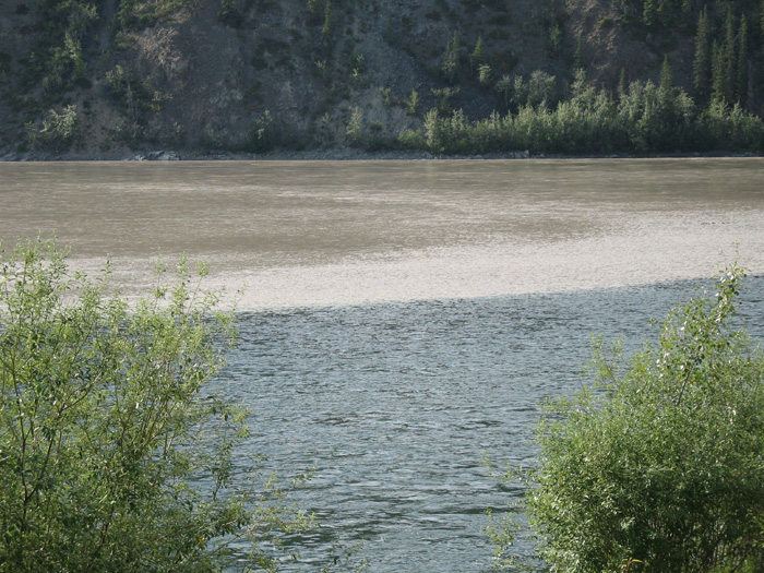
We did some shopping in town before heading home. On our way home, we stopped and took some pictures of the curious merge of Klondike and Yukon. It looks cool (no pun intended) when two differently colored waters fuse into one stream.

Two rivers merge: the Klondike is crystal clear while the Yukon looks like coffee with cream
We ate pot-luck with the other Airstream couples back at the campground. We did not stay up too late, since we were heading to Fairbanks the next morning. I made sure the truck was fueled before we parked, so that we would be able to leave very early.
[Next day] [Previous Day] [Main] [Summary]
All Pictures (c) 2006 Hamnqvist, Background features the Yukon Sky.